Overview
SenseOps is a visualisation and dashboarding app that integrates real-time data from different sources onto a single platform for situational awareness. It helps Government agencies to improve safe distancing and management efforts through more effective inter-agency planning, coordination and reporting. It was developed in 2020 in response to the COVID-19, which necessitated Safe Distancing and Safe Management measures. Currently, enforcement officers and Safe Distancing Ambassadors are deployed island-wide daily to ensure that citizens and businesses observe these measures.
SenseOps is part of the Smart Nation Sensor Platform (SNSP), a whole-of-government (WOG) technology platform that transforms sensor data into 360° situational awareness of smart city spaces in Singapore.
What is SenseOps?
SenseOps was built using visualisation and dashboarding technologies in the SNSP Framework (SNSP’s tech stack). SNSP’s scalable technologies form the building blocks to develop new apps serving different needs across the Singapore Government. The various features of SenseOps are as shown below.
One platform for all data
SenseOps’ dashboard pulls in relevant and real-time data from different sources and integrates it into one platform for easy visualisation. Data presented include safe distancing cases and crowd population.
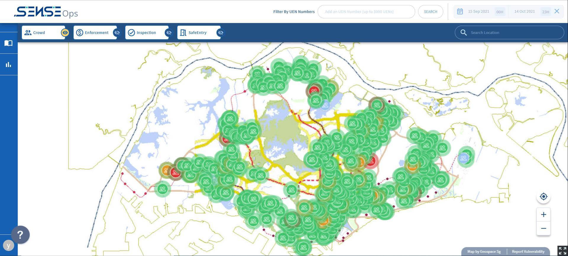
SenseOps features both map and dashboard layers, each of which offers different information and capabilities for agencies’ situational awareness.
Map layer
This feature helps to identify crowded hotspots, safe distancing cases, and discern patterns within the data in relation to parameters like crowd levels and time of the day.

Dashboard layer
This feature helps to summarise the safe distancing situation on the ground in real-time, observe trends in safe distancing operations over time, and automate reporting with built-in charts and graphs.
Why Should SenseOps be Adopted?
SenseOps’ visualisation and dashboarding features make it an effective tool for inter-agency safe management and distancing enforcement planning, operations, and reporting. Its benefits to Government agencies are as shown below.
WOG situational awareness
-
SenseOps provides Government agencies with up-to-date information on WOG coordinated COVID-19 operations, including hotspot locations, and visualises them on a map and dashboard for efficient sense-making.
Targeted planning and deployment
-
SenseOps enable Government agencies to plan the deployment of officers and ambassadors on the ground based on real-time information. For example, SenseOps visualises real-time crowd levels at different locations on a map, allowing agencies to deploy more Safe Distancing Ambassadors at common hotspots.
-
It also allows the Calibration of enforcement strategies based on past trends, such as hotspots of past Safe Distancing cases, for more targeted enforcement.
Efficient analysis and reporting
-
Agencies can use automated reports with built-in charts and graphs, reducing time and effort on consolidating information.
-
Agencies can also employ metrics of interest to help senior management grasp complex situations quickly, aiding in their decision-making.
How Do You Use SenseOps?
For onboarding to SenseOps as users or enquiries on the usage of SenseOps, Government agencies can email snsp_service_desk@tech.gov.sg. Our operations team will provide a form for you to fill up and submit to create your SenseOps account and respond to any queries you may have.
Success Stories
SenseOps currently supports multiple government agencies for coordinated, inter-agency COVID-19 related operations.
Safe distancing operations
Government agencies use SenseOps to ease daily planning of safe distancing operations and automate reporting.
SenseOps has helped agencies visualise hotspots and identify trends in safe distancing cases. This has allowed agencies to deploy Safe Distancing Ambassadors to hotspots more efficiently and increase the outreach and education of safe distancing measures to the public.
Safe management operations
SenseOps also supports inter-agency situational awareness for agencies involved in safe management operations. Relevant agencies use SenseOps to automate planning and reporting between them – significantly reducing silos which can cause overlaps in their operations.
What's Next?
SenseOps’ visualisation and dashboarding technologies allow different agencies to gain insights from the same datasets, and coordinate inter-agency planning by sharing and analysing their different datasets on one platform. SenseOps could also be expanded to include more data features for government agencies.
We are also developing new features to further enhance SenseOps’ capabilities to provide situational awareness and streamline operational and reporting processes such as:
-
Search by drawing an area on the map
-
Accessibility to control features for datasets
-
Notification features when data meet set rules
Contact Information
Reach out to the product team with your queries or feedback through this form.
Last updated 24 October 2023
Thanks for letting us know that this page is useful for you!
If you've got a moment, please tell us what we did right so that we can do more of it.
Did this page help you? - No
Thanks for letting us know that this page still needs work to be done.
If you've got a moment, please tell us how we can make this page better.

